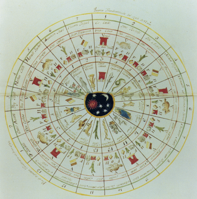
This highly accurate calendar was developed by the people of Mexico prior to 1492. The tonalpohualli, or sacred calendar, ruled the life of each Mexica and was consulted on all important occasions. It was made up of 260 days, or 20 months of 13 days.
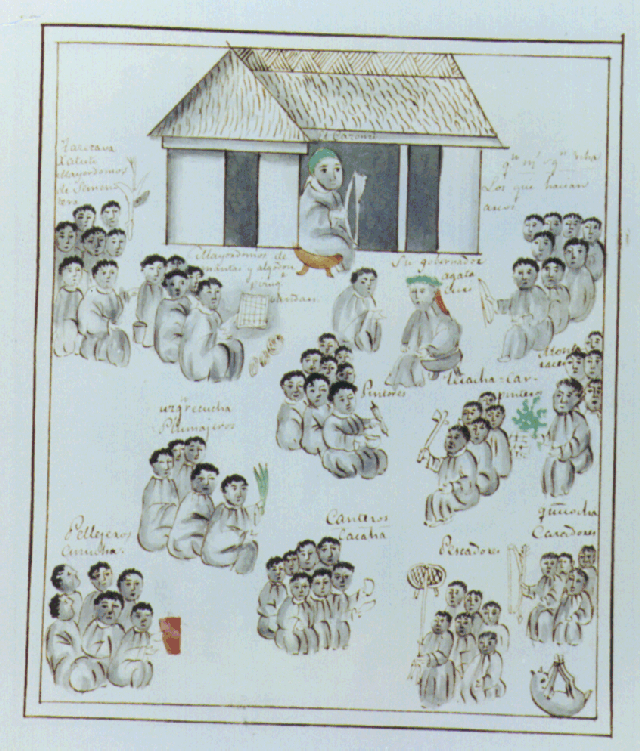
The Tarascans inhabited Michoacan, an area west of Tenochtitlan (present-day Mexico City) and south of Guadalajara. This illustration depicts schematically various occupational groups existing before the coming of the Spanish. Groups of figures sit, each with an object or symbol such as a net, a loom, a bow and arrow, a writing instrument, feathers, etc., that identifies the occupation of a specific group. A couple of figures in the upper part of the illustration sit alone and are identified as being the Cazonci or su governador (their governor).
This well-illustrated manuscript from Mexico chronicles the history and customs of the Tarascan people before as well as during the Conquest in the area of Michoacan. Although written by a Franciscan friar, it is largely based on the accounts of informants among the Tarascan nobility and priests, thus essentially expressing an indigenous point of view. The text and numerous illustrations describe the government, customs, and elaborate society of the Tarascan people.
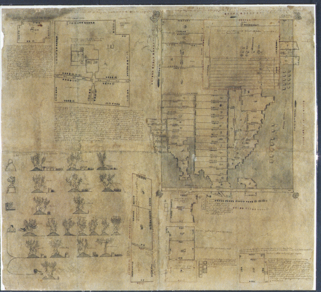
The Oztoticpac (Mexico) Lands Map is a central Mexican pictorial document with Spanish and Nahuatl writing showing litigation surrounding the Oztoticpac estate within the city of Texcoco, ca.1540. Its glyph, a symbolic figure, corrresponds to the name "above the caves" ("oztotle," cave; "icpac," above), a hill stylized in the shape of a woman. The document on pre-European "amatl" paper invovles the land and property ownership of the ruler of Texcoco who was executed during the early days of the Spanish Conquest in the Central Valley of Mexico. The execution left in its wake litigation involving ownership of properties claimed by various sons of Nezahualpilli, the lords of Texcoco.
Most of the drawings on the map are plans of fields with indigenous measurements and place glyps. Near the upper left is the plan of several houses within a precinct. On the upper right is a map showing about seventy-five plots of land. Additional fields are drawn at the lower right. Nahuatl and Spanish descriptions as well as three long Nahuatl texts include mention of Tollancingo, Oztoticpac, Texcuco, Don Carlos, and Don Hernando.
In the lower left of the map are depictions of tree grafts showing European fruit tree branches grafted to indigenous tree trunks, uniquely displayed among all known Mexican Indian pictorial documents. Twenty trees, identified as pomegranates, quinces, apples, pears, etc., are shown. Also, as far as it is known, this is the earliest reocrds lawsuit or conflict in horticultural literature anywhere in the world.

 Continue the Voyage with